Santa Cruz Fire Cracker 10K run: Difference between revisions
From genomewiki
Jump to navigationJump to search
(course description) |
(add link to elevation profile image) |
||
| Line 40: | Line 40: | ||
<TR><TD ALIGN=RIGHT>10000</TD><TD ALIGN=CENTER>21</TD><TD ALIGN=LEFT>slight downhill to the finish line</TD></TR> | <TR><TD ALIGN=RIGHT>10000</TD><TD ALIGN=CENTER>21</TD><TD ALIGN=LEFT>slight downhill to the finish line</TD></TR> | ||
</TABLE> | </TABLE> | ||
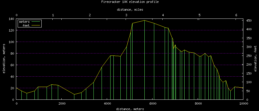
[[Image:FireCracker10KElevationProfile.png|course elevation profile]] | |||
Revision as of 22:23, 30 June 2012
| Santa Cruz Fire Cracker 10K run, course description | ||
|---|---|---|
| distance meters | altitude meters | course situation |
| 0 | 21 | starting line, Harvey West Blvd, just east of the pool entrance |
| 472 | 11 | gentle downhill on Harvey West Blvd then right on Coral St. |
| 815 | 15 | slight uphill, then right on Evergreen |
| 963 | 22 | minor peak in Evergreen St. |
| 1347 | 22 | slight downhill passing the finish line |
| 1569 | 26 | a small rise to right on Dubois St. |
| 1851 | 25 | slight downhill to right on Encinal St. continue gentle downhill to |
| 2561 | 9 | lowest point of the course, left at Hwy 9/River St. uphill from here |
| 2875 | 12 | left on Golf Club Dr. steady uphill from here to the Clubhouse |
| 3420 | 30 | Pogonip Park gate |
| 3777 | 56 | right curve, steady uphill |
| 4158 | 76 | Water station, left behind the Clubhouse Brayshaw Trail |
| 4293 | 76 | respite from the uptill, left onto Praire Trail level across the meadow |
| 4602 | 75 | right onto Pogonip Creek Trail again with the uphill |
| 4860 | 92 | rejoining Brayshaw Trail, begin steepest part of the hill |
| 5039 | 117 | midpoint of the hill walking with large steps is as fast as trying to jog here |
| 5115 | 132 | top of the hill, left on Spring trail |
| 5650 | 137 | rock wall on Spring trail, highest point of the course downhill from here |
| 6699 | 124 | entering Spring Street, water station, steep street downhill watch your step |
| 6931 | 88 | Spring St. dip in the road |
| 7034 | 91 | Spring St. slight rise in the road |
| 7222 | 85 | left on Highland St. |
| 7301 | 83 | left on Ross St. |
| 7420 | 86 | slight rise to top of Ross St. |
| 7616 | 82 | left on Highland St. |
| 7836 | 81 | right on Estates, neighbors playing music here |
| 8066 | 75 | bottom of Estates |
| 8140 | 75 | left on Roger Dr |
| 8320 | 80 | right on Highland St. |
| 8477 | 74 | dip by Eucalyptus trees, Highland St. beware steep downhill, watch your step |
| 8971 | 36 | left at High St. |
| 9114 | 30 | left into the path by the Hwy 1 freeway |
| 9236 | 33 | slight peak in path |
| 9335 | 20 | significant downhill on the path, watch your step |
| 9434 | 15 | Coral at Evergreen St. corner again |
| 9619 | 22 | peak of Evergreen St. |
| 10000 | 21 | slight downhill to the finish line |
